This page of the US growing (up to and through the State of Indiana) is largely a Wikipedia article, because there were pictures to go along with it! The growth of the United States, starting with the Revolutionary War, can be easily researched for additional or confirming information. The straight information and maps come from THIS WIKI LINK.
Obviously, the country continued to expand after 1818, but this page, which relates to Pulaski County in Indiana, stops at 1818.
The additional information regarding Native American lands is from this author and is noted in red. This information can be found on other pages of this website, particularly the page relating to the formation of Indiana. It is included here, only to keep at the front of the readers’ minds that this land did not belong to European Americans first. That is always hard to imagine, because the history of our country is generally written from the perspective of the Europeans who conquered the land.
Final note: This page starts at the approximate beginning of the American Revolutionary War. Another page deals with colonial wars.
October 7, 1763: Britain Establishes Native American Reserve
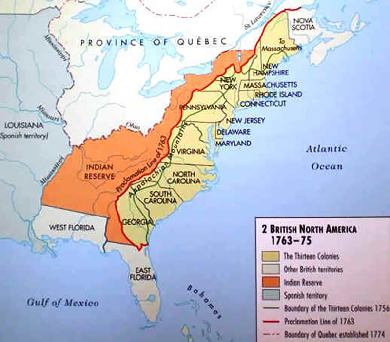
In response to Pontiac’s Rebellion, a revolt of Native Americans led by Pontiac, an Ottawa chief, King George III declared all lands west of the Appalachian Divide off-limits to colonial settlers. This royal proclamation, issued on October 7, 1763, closed down colonial expansion westward beyond Appalachia. The Proclamation was issued at the end of the French and Indian War to appease Native Americans by checking the encroachment of European settlers on their lands. It created a boundary, known as the proclamation line, separating the British colonies on the Atlantic coast from American Indian lands west of the Appalachian Mountains. In the centuries since the proclamation, it has become one of the cornerstones of Native American law in the United States and Canada.
1776–1784 (American Revolution)
July 4, 1776
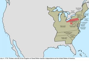 Thirteen colonies of the Kingdom of Great Britain in North America collectively declared their independence as the United States of America, though several colonies had already individually declared independence:
- The Colony of Connecticut, becoming the State of Connecticut.
- The Counties of New Castle, Kent, and Sussex, upon Delaware, commonly known as the Lower Counties on Delaware, which was Delaware Colony before their declaration of independence on June 15, 1776.
- The Province of Georgia, becoming the State of Georgia.
- The Province of Maryland, becoming the State of Maryland.
- The Province of Massachusetts Bay, becoming the State of Massachusetts Bay.
- The State of New Hampshire, which was the Province of New Hampshire before their declaration of independence on June 15, 1776.
- The Province of New Jersey, becoming the State of New Jersey.
- The Province of New York, becoming the State of New York.
- The Province of North Carolina, becoming the State of North Carolina; some believe the colony declared independence on May 20, 1775, but this is disputed
- The Province of Pennsylvania, becoming the State of Pennsylvania.
- The State of Rhode Island and Providence Plantations, commonly known as Rhode Island, which was the Colony of Rhode Island and Providence Plantations before declaring independence on May 4, 1776
- The Province of South Carolina, becoming the State of South Carolina.
- The Colony of Virginia, becoming the Commonwealth of Virginia.
The capital was not specifically established; at the time, the Continental Congress met in Philadelphia.
Many states had vaguely defined and surveyed borders; these are not noted as contested in the maps unless there was an active dispute. The borders of North Carolina were particularly poorly surveyed, its border with South Carolina having been done in several pieces, none of which truly matched the spirit of the charter, and its border with Virginia was only surveyed roughly halfway inland from the sea.
Several northeastern states had overlapping claims: Connecticut, Massachusetts Bay, and New York all claimed land west of their accepted borders, overlapping with each other and with a sizable claim by Virginia. Of the three, only Connecticut seriously pursued its claims, while Virginia is considered to have had the most legitimate claim to the vast northwest, dividing it into counties and maintaining some limited control.
The entirety of the new United States was claimed by Great Britain, including Machias Seal Island and North Rock, two small islands off the northeast coast which remain disputed up to the present.
September 20, 1776
The Counties of New Castle, Kent, and Sussex, upon Delaware enacted a constitution, renaming itself the Delaware State..
September 28, 1776
The State of Pennsylvania enacted a constitution, renaming itself the Commonwealth of Pennsylvania.
December 20, 1776
To avoid British forces who were advancing on Philadelphia, the Continental Congress began meeting in Baltimore.
January 15, 1777
The northeastern region of New York, known as the New Hampshire Grants, declared independence as New Connecticut..
March 4, 1777
The Continental Congress returned to Philadelphia after the threat to it by British forces was ended.
June 4, 1777
New Connecticut was renamed Vermont.
September 27, 1777
The Continental Congress fled Philadelphia after the American defeat at the Battle of Brandywine, and briefly met in Lancaster, Pennsylvania.
September 30, 1777
The Continental Congress continued to move away from Philadelphia, settling in York, Pennsylvania.
June 11, 1778
Vermont claimed what was called the “East Union,” consisting of some towns in New Hampshire that petitioned on March 12, 1778, to join with Vermont due to a concern that their state was focusing too much on its coastal region. Vermont never gained full control over the area.
October 21, 1778
Due to pressure from the Continental Congress, Vermont rescinded the annexation of the East Union; the legislature declared on February 12, 1779, that the East Union should be considered null from its beginning.
July 2, 1779
The Continental Congress returned to Philadelphia following British withdrawal.
August 31, 1779
Virginia surrendered its claim to southwest Pennsylvania.
March 1780
North Carolina and Virginia surveyed their border further inland. Virginia’s survey reached to the Tennessee River, but North Carolina’s only went as far as the Cumberland Gap, and as the two surveys were roughly two miles apart, this created a thin area claimed by both states. While the border was intended to follow 36 degrees 30’ north, early surveying errors caused it to veer north of that, reaching a distance of seventeen miles off by the time it reached the Tennessee River.
October 25, 1780
The State of Massachusetts Bay enacted a constitution, renaming itself the Commonwealth of Massachusetts.
March 1, 1781
The Articles of Confederation entered into force.
August 4, 1781
Vermont again claimed an East Union, consisting of some towns in New Hampshire that wished to join with Vermont; more towns were interested than during the first attempt in 1778, though again, the exact extent of the borders is unknown. Vermont never gained full control over the area.
June 16, 1781
Vermont claimed what was called the “West Union,” consisting of some towns in New York, mainly to counterbalance Vermont’s attempt at eastward expansion. Vermont never gained full control over the area. The specific date this occurred is unclear; sources suggest June 16, June 26 and July 18.
February 22, 1782
Vermont abandoned its attempts to annex the East Union from New Hampshire and the West Union from New York.
October 29, 1782
The federal government accepted the cession from New York of its western claims, which the state ceded on February 17, 1780; New York proclaimed its new western border to be a line drawn south from the western end of Lake Ontario. At its maximum interpretation, the state had claimed an area bounded by Lake Erie, Lake Huron and Lake Michigan; to the Illinois, Mississippi, and Tennessee Rivers; and north along the Appalachian Mountains, ending at the border with Pennsylvania. It is unclear from where this claim came; many sources state that New York had surrendered it, but very few elaborate on how it was obtained. One source states that it was a cession by the Six Nations, who had conquered much of the region. However, New York never seriously enforced these claims. The cession included the small tip of New York north of Pennsylvania, which came to be known as the Erie Triangle.
December 30, 1782
The Congress of the Confederation declared that the land Connecticut claimed in northern Pennsylvania was part of Pennsylvania, thus attempting to end the Pennamite-Yankee War. The claim was an extension of Connecticut’s northernmost and southernmost borders westward, skipping New Jersey and New York, though as Connecticut’s northern border was a few miles north of Pennsylvania’s northern border, a small sliver of New York was also claimed. While conflict would continue for some time, this was the end of the formal claim by Connecticut.
June 30, 1783
The Pennsylvania Mutiny of 1783, and the Pennsylvania government reaction to it, caused the Congress of the Confederation to leave Philadelphia for Princeton.
November 26, 1783
The Congress of the Confederation reconvened to Annapolis.
March 1, 1784
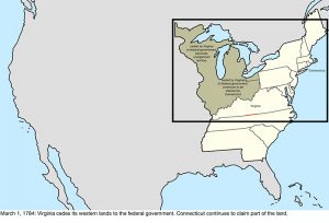 Virginia ceded its claims northwest of the Ohio River to the federal government. Connecticut continued to claim its western lands that had overlapped Virginia’s cession.
May 12, 1784
Great Britain recognized the independence of the United States, ending its claim to the country. The treaty ended the American Revolutionary War, though military action had largely ended after the Franco-American victory at Yorktown on October 19, 1781.
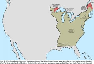 Because of ambiguities and poor knowledge of geography, the treaty was unclear in several areas:
- The northeastern border was defined as running from the headlands of the Croix River, but there were several options for that.
- The northwestern border was defined as a line running west from the northwestern point of the Lake of the Woods to the Mississippi River, but the river’s source was south of that; maps universally show the line as running directly from the Lake of the Woods to the river’s source, Lake Itasca.
- The border extending from Lake Superior towards the Lake of the Woods was poorly defined as starting from “Long Lake”, which both sides interpreted to their advantage.
- Machias Seal Island and North Rock off the northeast coast remained disputed, as did Sugar Island off the Upper Peninsula of Michigan.
The Peace of Paris also involved treaties with France and Spain, with Great Britain ceding the Floridas to Spain. During their ownership of West Florida, the British had moved its border north, and the cession to Spain appeared to apply to the full extent of the British colony. However, the British-American treaty granted the extension of West Florida to the United States, where it enlarged Georgia south to 31° north, indicating that only the original definition of West Florida was to be ceded to Spain. The local Spanish governors also made a move to occupy forts along the Mississippi River, with claims to everything south of the Tennessee River; it is unknown how official or strong these claims were, and they are not mapped as they are in conflict with the other Spanish claim involving the border of West Florida.
1784–1803 (Organization of territory)
August 23, 1784
A region in central North Carolina (modern-day eastern Tennessee), unhappy with the state’s governance over the area, declared independence from the state as the State of Frankland. The government of Frankland held some control over the area, and petitioned for statehood, receiving support from seven of the nine states required, but would only last a few years.
November 1, 1784
The Congress of the Confederation moved for a short time to Trenton.
1785 – 1795: Northwest Indian War
The US Army considers the Northwest Indian War the first of the United States Indian Wars. The US Army fought a united group of Native Americans, known today as the Northwestern Confederacy, sometimes as the Western Confederacy.
Centuries of conflict for control of this region preceded the Northwest Indian War. In the years preceding the Revolutionary War, the British had set aside this land as a reservation for Native Americans. After the War, the land was ceded to the United States with no mention of its Native American inhabitants. The treaty set the Great Lakes as a border between British territory and the US. It was known as the Ohio Country and the Illinois Country.
January 11, 1785
The Congress of the Confederation moved to New York, and would settle there for five years.
April 19, 1785
The federal government accepted the cession from Massachusetts of its extreme western claim, which was never seriously enforced.
June 1785
The State of Frankland was renamed the State of Franklin, to encourage Benjamin Franklin to endorse the state, though he declined.
September 13, 1786
Connecticut surrendered its western claim to the federal government except for its Western Reserve, though it is unclear how much control they held over the ceded region.
December 16, 1786
Massachusetts surrendered its claim to western New York, though it is unclear if Massachusetts ever held control over the region, as the claim was to the “soil, not the sovereignty.” This land was later known as the Phelps and Gorham Purchase.
July 13, 1787
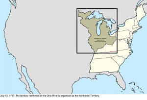 The Territory northwest of the Ohio River, ceded earlier by Virginia, was organized and commonly became known as the Northwest Territory.
August 9, 1787
South Carolina ceded its western claim to the federal government, though it was a result of inaccurate geography and South Carolina never actually held claim to this land. The claim was of a strip of land between the border of North Carolina and the source of the Tugaloo River but, unknown at the time, the river originated in North Carolina. The eastern part of this cession would be given to Georgia in 1802, despite Georgia technically already having claim to the land.
December 7, 1787
Delaware became the first state to ratify the United States Constitution.
December 12, 1787
Pennsylvania became the second state to ratify the Constitution.
December 18, 1787
New Jersey became the third state to ratify the Constitution.
January 2, 1788
Georgia became the fourth state to ratify the Constitution.
January 6, 1788
Connecticut became the fifth state to ratify the Constitution.
February 6, 1788
Massachusetts became the sixth state to ratify the Constitution.
April 28, 1788
Maryland became the seventh state to ratify the Constitution.
May 23, 1788
South Carolina became the eighth state to ratify the Constitution.
June 21, 1788
New Hampshire became the ninth state to ratify the Constitution; at this point, the Constitution became the active governing document of those nine states having ratified the same (per Article VII).
June 25, 1788
Virginia became the tenth state to ratify the Constitution.
July 26, 1788
Virginia became the tenth state to ratify the Constitution.
February 1789
John Sevier, governor of the State of Franklin, pledged allegiance to North Carolina, effectively ending the claimed independence of Franklin.
August 7, 1789
The Northwest Territory was reorganized under the Constitution.
November 21, 1789
North Carolina became the twelfth state to ratify the Constitution.
April 2, 1790
North Carolina ceded its western half to the federal government.
May 26, 1790
The land recently ceded by North Carolina was organized as the Territory South of the River Ohio, commonly known as the Southwest Territory.
May 29, 1790
Rhode Island became the thirteenth state to ratify the Constitution.
December 6, 1790
Per the Residence Act, the Congress of the United States relocated to Philadelphia for ten years until a federal district was built and ready.
March 4, 1791
Vermont, which had been considered part of New York despite acting independently since 1777, was admitted as the fourteenth state.
March 30, 1791
The District of Columbia, a federal district planned to house the federal government by 1800, was formed from land ceded by Maryland and Virginia, consisting of a 100 square mile diamond, with its southern tip at Jones Point, straddling the Potomac River. However, it was not yet given that name, being simply referred to as the federal district. In September 1791, the commissioners in charge of planning the city would term it the “Territory of Columbia”, and various laws refer to a District of Columbia, but sometimes informally. The area does not appear to have been formally named “District of Columbia” until at least the organic act of 1871. Since the name “Columbia” was used from very early on, and at least informally by the government, the map will use “District of Columbia” starting from this date.
March 3, 1792
Pennsylvania purchased the Erie Triangle from the federal government.
June 1, 1792
The western half of Virginia, which the state had agreed in 1789 to cede to the federal government, was admitted as the fifteenth state, Kentucky.
June 12, 1792
The Delaware State enacted a new constitution, renaming itself the State of Delaware.
1795: Treaty of Greenville
The Treaty of Greenville ended the Northwest Indian War in Ohio Country and redefined the boundary between Native peoples’ lands and territory for European American community settlement.
August 3, 1795
Representatives of the United States and the Western Confederacy sign the Treaty of Greenville, ending the Northwest Indian War and ceding most of the modern state of Ohio to United States control.
February 29, 1796
Great Britain agreed to abandon several forts in the northwest that it still occupied, including Detroit. The Jay Treaty also provided for commissions to determine the border between the northwestern point of the Lake of the Woods and the source of the Mississippi River, and which river to consider the St. Croix River.
April 25, 1796
The northern half of West Florida was ceded by Spain, resolving the dispute over the region.
June 1, 1796
The Southwest Territory was admitted as the sixteenth state, Tennessee.
April 7, 1798
Due to the Yazoo Land Fraud, an act authorized President John Adams to appoint commissioners to negotiate with Georgia about ceding its western land. The act created Mississippi Territory from the southwestern quarter of Georgia in the region recently ceded by West Florida, while maintaining that Georgia still held rights over the territory.
October 25, 1798
Commissioners agreed on the source of the St. Croix River, setting the lower portion of the border between Massachusetts and Great Britain and, thus, where the eastern north–south line originated.
June 9, 1800
Connecticut ceded its Western Reserve to the federal government, which assigned it to the Northwest Territory. The act doing so was passed in Congress on April 28, 1800, and Connecticut approved it on this date.
July 4, 1800
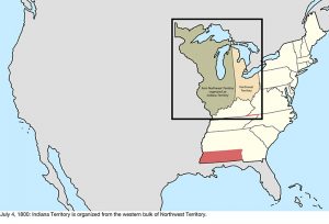 Indiana Territory was organized from the western half of Northwest Territory.
November 17, 1800
The Congress of the United States moved to Washington in the District of Columbia, now built and ready to be the capital. This was two weeks before the December 1 date established in the Residence Act; President John Adams urged Congress to move early in hopes of securing enough Southern votes to be re-elected, though this failed.
January 1, 1801
The Kingdom of Great Britain united with the Kingdom of Ireland, renaming itself the United Kingdom.
February 27, 1801
The District of Columbia was organized.
April 26, 1802
Georgia ceded its western half, known as the Yazoo Lands, to the federal government. At the same time, the federal government ceded to Georgia the eastern portion of the land previously ceded by South Carolina, though in reality Georgia technically already held title to the land, as the description of the earlier cession was based on an erroneous understanding of geography.
1803: First Treaty of Fort Wayne
This treaty more precisely defined the boundaries of the Vincennes tract ceded to the United States by the Treaty of Greenville, 1795.
March 1, 1803
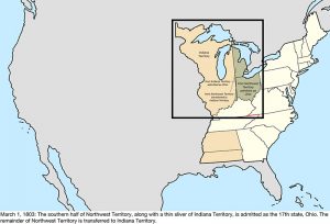 The southern half of the Northwest Territory, along with a thin sliver of Indiana Territory, was admitted as the seventeenth state, Ohio. The remainder of the Northwest Territory was transferred to Indiana Territory. The western border was a line due north from the mouth of the Great Miami River; the federal definition of the northern border was a line drawn east from the southern tip of Lake Michigan, whereas the Ohio Constitution stated the line should run from the southern tip of Lake Michigan to the most northerly cape of Maumee Bay, essentially the western tip of Lake Erie. The confusion caused by these varying descriptions of the state’s borders, combined with inaccurate knowledge of geography, as no one at the time knew just how far south Lake Michigan extended, would lead to the conflict over the Toledo Strip.
November 3, 1803
The border between Tennessee and Virginia was resurveyed and established, ending the dispute over that part of the border. The border between Kentucky and Tennessee, despite following the original survey, remained vaguely defined.
1803–1818 (Purchase of Louisiana)
December 20, 1803
The United States purchased Louisiana from France. This is the date of the formal turnover in New Orleans; the purchase was completed on April 30, 1803. The transfer would be recognized in St. Louis in Upper Louisiana on March 10, 1804, known as Three Flags Day.
The acquisition expanded the United States to the whole of the Mississippi River basin, but the extent of what constituted Louisiana in the south was disputed with Spain: the United States claimed the purchase included the part of West Florida west of the Perdido River, whereas Spain claimed it ended at the western border of West Florida; and the southwestern border with New Spain was disputed, as the United States claimed the Sabine River as the border, but Spain maintained it was the Calcasieu River and others.
1804: Treaty of Vincennes
The Treaty of Vincennes is the name of two separate treaties. One was an agreement between the US and the Miami and their allies, the Wea tribes and the Shawnee. The purpose of the treaty was to get the native tribes to formally recognize the American ownership of the Vincennes Tract, a parcel of land captured from Great Britain during the Revolutionary War.
The second treaty was to purchase land from the tribes. The area purchased was south of the Vincennes tract and the Buffalo Trace, north of the Ohio River and east of the Wabash River. The treaty had the effect of connecting Clark’s Grant and the Vincennes Tract. The area had many squatters living on native owned lands which led to rising tensions with the tribes; the treaty relieved pressure on the settlers, allowing them to freely settle the land.
1804
The “Southwick Jog” was transferred from Connecticut to Massachusetts, to put to rest long-standing disagreements over the border between the two states.
March 27, 1804
The land between Tennessee and Mississippi Territory previously ceded by Georgia was assigned to Mississippi Territory.
October 1, 1804
Orleans Territory was organized from the Louisiana Purchase south of 33° north, with the remainder being designated the District of Louisiana and placed under the jurisdiction of Indiana Territory.
1805: Treaty of Grouseland
This treaty was between the US, negotiated by Indiana Territory Governor William Henry Harrison with Little Turtle (Miami) and Buckongahelas (Lenape). It was negotiated and signed at Harrison’s home in Vincennes, called Grouseland. It was the second major land purchase in Indiana since the close of the Northwest Indian War and the signing of the Treaty of Greenville.
June 30, 1805
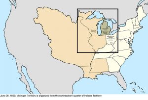 Michigan Territory was organized from Indiana Territory, north of a line east from the southern tip of Lake Michigan, and east of a line north from the lake’s northern tip. The southeastern portion of the border technically conflicted with the definition of Ohio, which claimed the Toledo Strip north of that line; however, the exact position of Lake Michigan was not yet known.
July 4, 1805
The District of Louisiana was organized as Louisiana Territory.
1809: Second Treaty of Fort Wayne
In September 1809, Potawatomi, Delaware, Miami and Eel River tribal leaders signed the Treaty of Fort Wayne, ceding approximately 3 million acres of land in Ohio, Illinois, Indiana and Michigan for 2 cents an acre. The treaty ultimately brought an end to peace between the Unites States and many Native Nations, creating a divide that contributed to the start of the War of 1812.
March 1, 1809
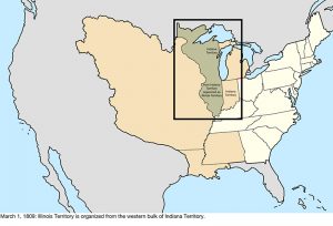 Illinois Territory was organized from the western half of Indiana Territory.
September 26, 1810
The Republic of West Florida declared independence from Spain, claiming the area of West Florida west of the Perdido River. It maintained some control over its territory.
December 10, 1810
Armed forces led by William C. C. Claiborne took possession of the portion of West Florida west of the Pearl River, following a proclamation on October 27, 1810, by President James Madison to do so. The United States had considered the region part of the Louisiana Purchase, including the area which had revolted against Spanish Florida and formed the Republic of West Florida. Madison’s proclamation stated that it was to be “taken as part” of Orleans Territory. The land west of Mobile Bay to the Pearl River was occupied and annexed de facto by the military in 1811.
1811 – 1815: Tecumseh’s War
Tecumseh was a Shawnee leader who brought Native nations together around his brother’s teachings to fight against further erosion of Native lands to US settlers. His brother Tenskwatawa – also known as The Prophet – believed Natives had angered the Master of Life. Natives had become reliant on American goods, such as alcohol, iron cookware and guns. He advocated a return to the traditional Shawnee way of life. The Battle of Tippecanoe in 1811 is viewed by many as the first battle of the War of 1812.
1812 – 1814: War of 1812
The War of 1812 could have been the War of Indian Independence. It was a major turning point for Native Americans who struggled to keep their lands and their culture.
1812: Battle of Fort Dearborn
Before Chicago was platted, Fort Dearborn sat at the confluence of the Chicago River and Lake Michigan. A bloody battle took place here between the Potawatomi and US troops in August of 1812. The battle was a decisive victory for the Potawatomi.
1812: Peoria War
A nearly forgotten series of small skirmishes became known as the Peoria War (Illinois).
April 30, 1812
Most of Orleans Territory was admitted as the eighteenth state, Louisiana. The southeastern remainder presumably became unorganized territory, as it had no definition for a short time.
May 14, 1812
The claimed portion of West Florida east of the Pearl River was assigned to Mississippi Territory, though the area around Mobile Bay remained under the control of Spanish Florida. The United States militarily occupied Mobile and the surrounding area up to the Perdido River in April 1813.
June 4, 1812
Since its name was now shared with the state of Louisiana, Louisiana Territory was renamed Missouri Territory.
August 4, 1812
The remaining claimed portion of West Florida, west of the Pearl River, was added to Louisiana, following the assent of that state to an act passed by Congress on April 14, 1812.
August 16, 1812
During the War of 1812, the garrison at Fort Detroit surrendered, leading the United Kingdom to occupy Detroit, the capital and population center of Michigan Territory.
September 29, 1813
The British withdrew from Fort Detroit following the Battle of Lake Erie, allowing American forces to regain control over Michigan Territory.
August 24, 1814
British forces capture and burn Washington, but are forced to withdraw the next day. The functions of the capital were only momentarily suspended, though President James Madison took refuge in Brookville, Maryland.
December 11, 1816
The southern part of Indiana Territory, along with small parts of Illinois Territory and Michigan Territory, were admitted as the nineteenth state, Indiana. The remainder of Indiana Territory across Lake Michigan became unorganized territory.
March 3, 1817
Alabama Territory was organized from the eastern half of Mississippi Territory.
December 10, 1817
Mississippi Territory was admitted as the twentieth state, Mississippi.
1818: Treaty of St. Mary’s
The Treaty of St. Mary’s may refer to one of six treaties concluded in fall of 1818 between the United States and Natives of central Indiana regarding purchase of Native land. The main treaty was with the Miami, who were the main tribe in Indiana. Unqualified references to the treaty usually refer to this one. The treaties acquired a substantial portion of the land area (dubbed the New Purchase) of the state of Indiana from the Miami, Delaware, Potawatomi and others in exchange for cash, salt, sawmills, and other goods. The treaties effectively moved the northern boundary of the state from near the Ohio River to the Wabash River in the northwest and north. They also resulted in creation of Indian reservations and continued the process of Indian removals in Indiana begun by the Treaty of Greenville in 1795.
February 6, 1818
Alabama Territory created Tuskaloosa County with a description that inadvertently overlapped with Mississippi. It described the border of the county as running “a due west course to, the Tombeckbe river; thence up the same to the Cotton Gin Port”. Unknown at the time, the origin of the Tombigbee River and Cotton Gin Port were in Mississippi.
June 30, 1818
Per the terms of the Treaty of Ghent ending the War of 1812, the United Kingdom returned Moose Island to Massachusetts, and the United States returned Campobello Island, Deer Island, and Grand Manan Island to the United Kingdom, all of which were captured from the other side during the war.
December 3, 1818
The half of Illinois Territory south of 42°30′ north was admitted as the twenty-first state, Illinois. The remainder of the territory, along with the unorganized territory that was recently part of Indiana Territory, was assigned to Michigan Territory.
The Series
-
- Indigenous Peoples of Pulaski County
- The Land, From Ice To European Arrival
- The People, From Ice To European Arrival
- Europeans Arrive
- French Fur Trade & The Beaver Wars
- Indian Wars, Pre-Revolutionary War (The Colonial Wars)
- Revolutionary War
- Indian Wars, Post-Revolutionary War
- United States Takes Shape
- Indiana Takes Shape
- Pulaski County Takes Shape
- Indian Removals, 1700 – 1840
- The Potawatomi, Keepers Of The Fire
- Trail Of Death
- The Chiefs Winamac
- 7 Fires of the Anishinaaabe