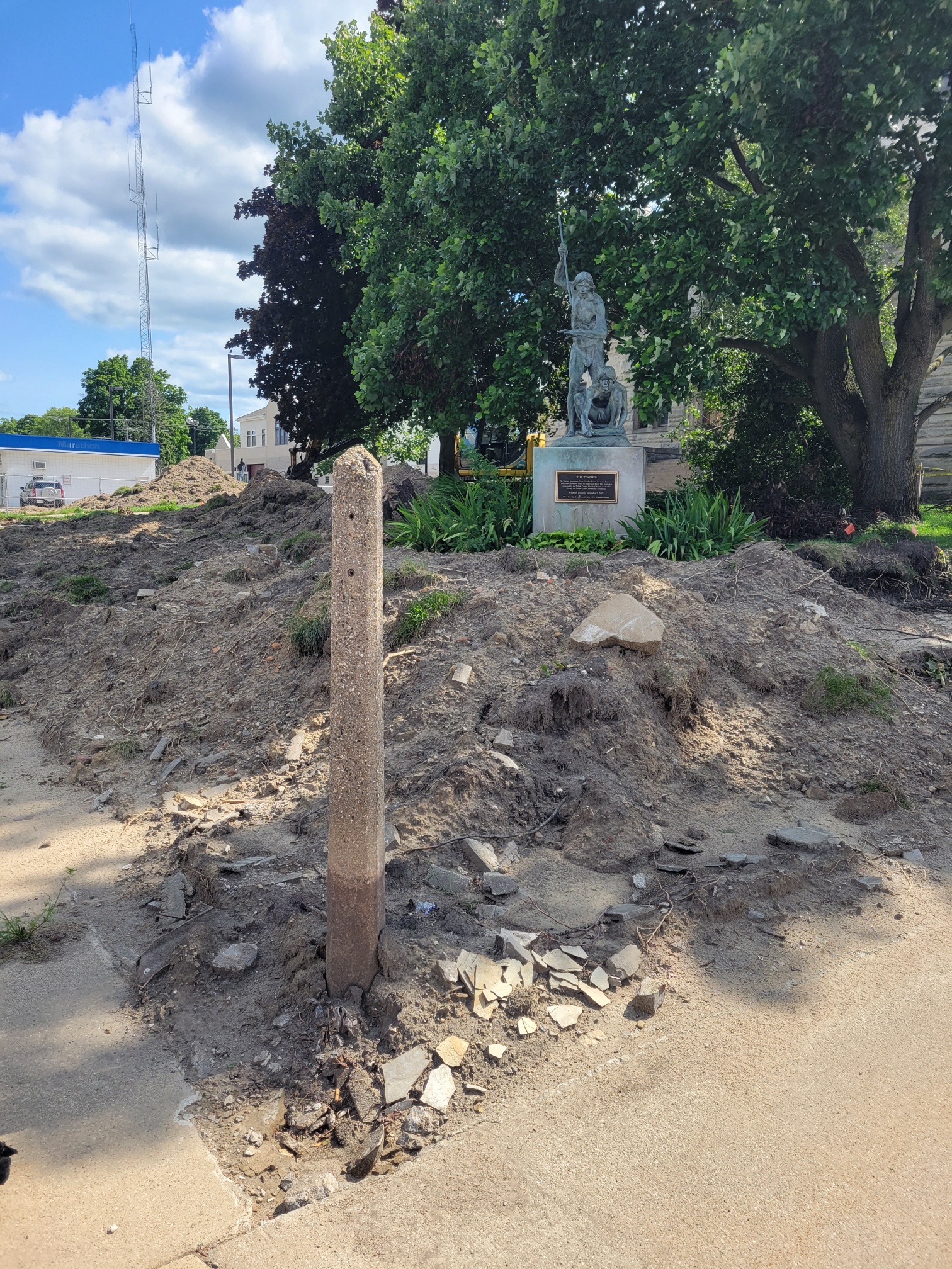
During the Courthouse renovations, a question was asked about this monolith, found at the northeast corner of the lot at the intersection of Main Street and Monticello Street.
This appears to be one of the original survey markers for the town.
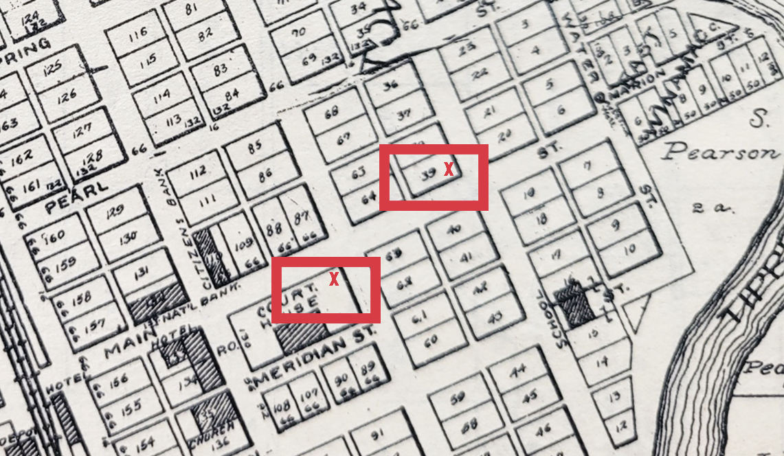
When the town was platted, the first survey marker was placed on “the South East corner of J P. Rowans Store Building being on Lot 39.” This was the corner of Main Street and Front Street (now Riverside Drive). Lot 39 faces Front Street, although the house standing there now makes it appear to face Main Street.
At that time, Front Street was the principal – and possibly the only – commercial and residential street in Winamac. Front Street followed the river. Original and well-known residents – Pearson, Rowan, and Key, among others – lived along Front Street.
Also at that time, the main crossing of the Tippecanoe River was at Pearl Street, just off Front Street. Crossings of people and livestock were managed by ferry.
What we now know as “downtown” didn’t build up until the railroad came through in 1860-61.
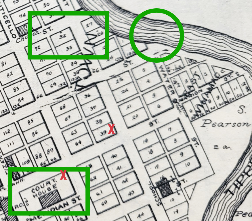
We will focus on four separate locations in this article. The plat map below shows downtown Winamac, with a few sections highlighted. The sections will be “sliced away,” allowing the reader to see the lot numbers more clearly.
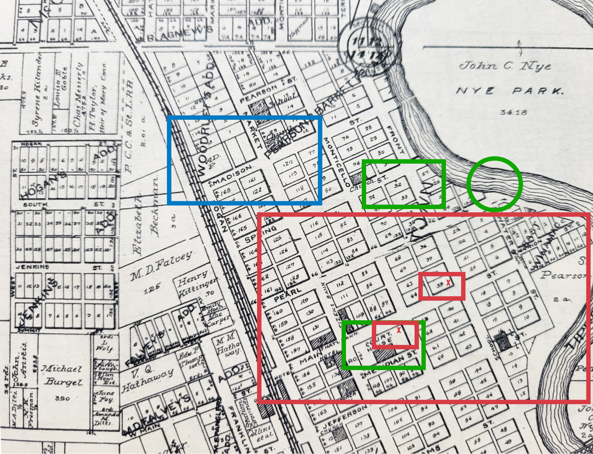
Below is an enlarged plat map of the section highlighted in red. It shows a closeup of the aforementioned lot 39 at the southeast corner of Main Street and Front Street (now Riverside Drive). Also noted is the location of the survey marker found at the northeast corner of the Courthouse, the corner of Main Street and Monticello Street.
From a post by the Historical Society in January 2024 [https://pulaskihistory.net/no-one-has-ever-found-winamacs-original-survey/], we find this information regarding the “first” surveyor in 1834, Robert G. Hanna. Mr. Hanna’s original survey maps and notes can be found on the Historical Society’s Museum website [http://museum.pulaskihistory.net/pulaski-county-begins/].
Pulaski County’s First Surveyor
One of the busiest men in these parts during the several years beginning with 1834 must have been Robert G. Hanna, who started making the original survey of this area for the Federal government that year. When the Pulaski County government was officially organized and established in 1839, Wm. H. Lemon became the County Surveyor. Surveyor’s Records dating back to Hanna’s original survey are still well preserved and legible in the Surveyor’s office,
Hanna first used posts to mark his section corners and half-mile points, county surveyors later going back to replace the posts with stones.
Winamac’s First Survey
Also from that January post comes a recitation from the Pulaski County Democrat, June 16, 1971. While the original plat maps of Pulaski County from 1834 are available, this article references the original plat maps of Winamac. The original Winamac maps would cover the survey marker found at the Courthouse square.
The Town of Winamac was laid out with a long chain in the original survey, according to one 19th century expert. Even more startling, no surveyor from 1866 on (and even prior to that according to written testimony) has succeeded in finding the ‘original survey’. This is only one bit of Pulaskiana coming to light from work in progress now by the County’s Surveyor’s office.
An act passed by the state legislature in 1965 mandated that each county relocate, re-establish and re-witness all the corners and subdivision markers of sections in the county. The rate of relocation was established at 5 percent per year, with a 20-year deadline to complete the job. The first relocations here were made under the supervision of former Surveyor John Sheppard. With the resignation of Sheppard in Feb. 1970, the work stopped, then resumed when William Butler was named part-time surveyor in February of this year.
Butler figures the job is about 30 percent completed and that some 1,700 markers must be found and re-established in the next 14 years.
Question: “Does the present relocation work anticipate solving Winamac’s non-existent survey lines?”
Butler: (with emphasis) “Negative”.
He went on to explain that the state has ordered only the relocating of county section corner and subdivision markers, but that this work could result in establishing a ‘point of origin’ for a re-survey (or, rather, ‘finding’ the original survey) of the Town of Winamac.
Winamac’s boundary problem is nowhere so explicitly and succinctly stated as in notations made in the Surveyor’s records by then Pulaski County Surveyor Russell Allen: one entered July 28, 1865, the other, March 16, 1866.
“Survey made of Town Lots in the Town of Winamac will have to be made with an addition of 2 1⁄3 inches to each chain in consequence of the Chain with which the original Survey was made being that much too long – the South East corner of J P. Rowans Store Building being on Lot 39 is accepted as on the original Survey corner of the Town. This Point having been accepted by D. Agnew, and followed by Hawes. Front Street runs N 28 degrees 26 minutes West in 1865 July 28th”. (signed) Russell Allen S.P.C.
A plausible reconstruction of events after that entry indicates that Allen: 1. Tried to re-establish the original survey using a ‘long chain’ and, 2. Gave it up as an impossible job. The next spring Allen entered this testimony in the record book:
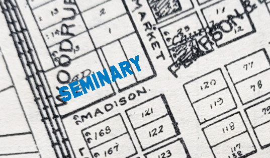
“In making further Surveys in the Town of Winamac, I find there has been a great error in which I find that I have, like my predecessor, failed in finding the original survey. At this time I find the record of the survey of the seminary lot on page 17 book. A surveyor’s record which gives a witness for the west Line of Market Street being the southeast corner of the seminary lot. I have deposited a stone at that point marked X. It will be found that the surveys made on Market street do not correspond with the above witness point. March 16, 1865” (signed) R. Allen S.P.C.
No one to this date has had any more luck than Allen.
Regarding the “Long Chain”
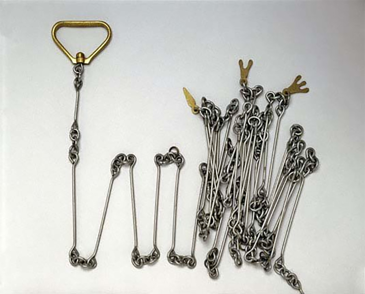 Again, this information can be found in the January 2024 post.
The Gunter’s Chain is a device that was first introduced in 1620 and was used to survey not only the British Empire, but also the wilderness and early American settlements. The Gunter’s Chain measures 66 feet in length and consists of 100 links usually marked off into groups of 10 by brass rings or tags. Though this device has become obsolete, its use has left an imprint on our nation’s history and how property has been measured and divided. The chain, the link, and the rod have all became statutory units of measurement that were made convenient by the Gunter’s Chain.
Apparently, the Gunter’s Chain used by the persons platting the town of Winamac was flawed.
Commissioners Establish Important Town and County Locations
This information can also be found in that January 2024 post.
The undersigned Commissioners, appointed by an act of the General Assembly of the State of Indiana, to locate the seat of justice of Pulaski County, met at the house of John Pearson, in the town of Winamac, on Monday, the 6th day of May, 1839, and after being duly sworn according to law, proceeded as follows, to wit: We have selected the town of Winamac as the seat of justice of Pulaski County, the court house to be on the court house square as designated on the plat of said town. We have further received of William Polk and John Pearson, proprietors of said town, as a donation, the public square as designated on the town plat.* Also an acre of ground [on which] to build a public seminary, on the north of Madison street and opposite Lots 121 and 168, being 280 feet on said street, and running at right angles back for quantity. Also, two acres of ground at some suitable point adjacent to the town for a public graveyard. Also, we [they] will further agree to donate for the purpose of a court house for said county Lot 33, on which is a good hewed-log house, erected 18×26 feet, for the term of four years from this date, after which it is to be considered the property of the proprietors, their heirs or assigns. Also, one note of $1,575, and payable in three years with interest from date. Also, one note of the same date and amount, payable in four years from date, with interest as aforesaid note of three years. Also, the sum of $125 to be paid at the first session of the Commissioners’ Court. Given under our hands and seals this 8th day of May, 1839. John Barr, James Gordon, David Martin, William Wardon, J. H. Kentner, Locating Commissioners.
* It is our understanding that the deal was made to donate these properties to the public domain in order for Winamac to become the county seat. Had the proprietors of Winamac not made the deal, perhaps Francesville or Medaryville would have become the county seat.
The town slice below – the one originally highlighted in blue – shows the location of the Seminary using Mr. Allen’s description. The historic Dr. George W. Thompson house is at that location.
The photo below shows the areas highlighted in green. The green ellipse shows the location where ferries moved both people and livestock from the town to the grazing area owned by John Nye, now the town park.
The original Courthouse, per these notes, was on Lot 33, which held the “good hewed-log house.” It held both the first circuit court and a school. Lot 33 faces Front Street and is located six lots north of the first survey marker at Front and Main Streets. It is also very close to what then was “downtown,” with most of the town’s residences and several small businesses.
Lot #33’s claim to fame as a courthouse was short-lived, from 1839 to 1849.
Two things happened in 1843. First, the construction of the first log schoolhouse was completed on Lot 159 (on Logan Street, just south of Pearl Street). This moved the school away from the good-hewed log house. That same year, construction began on the first courthouse to be located on the courthouse square, a two-story frame building. The county ran out of money; the building was not completed until 1849.
[Note: The county first leased lot 33 for a period of four years, until 1843. One could probably go through Commissioners’ notes and find a lease extension, but that will be left for another day.]
The second courthouse to stand on the square, a two-story brick building, was completed in 1862. The county jail, a separate building, stood alongside it on the square. The courthouse was under construction as the railroad came to town, which made possible the purchase and delivery of bricks.
The current courthouse, the third to stand on the courthouse square – and now under renovation – came along shortly after. Architectural plans were selected in 1894, and it was completed in 1895.
Through all the changes, the original survey marker remains in the same place.
In Conclusion
In short, the survey marker about which this article is written marked the location of the original public square. While it was a short distance from what – in 1839 – was the focal point of downtown, this location was intended from “the 6th day of May, 1839” to be the seat of county government.
Thus the sturdy and distinctive marker.
Per all other accounts, the plat measurements were probably off due to an extra-long Gunter’s Chain. Today, that doesn’t seem to matter.
Many thanks to Nathan Origer for supplying the photograph of the survey marker!